File:First century Iudaea province.gif
Versione a risolutzione arta(575 × 792 pixels, mannesa de su file: 31 KB, tipu de MIME: image/gif)

Custu documentu benit dae Wikimedia Commons e podet èssere impreadu in àteros progetos. A sighire est ammustrada sa descritzione in sa sua pàgina de descritzione de su documentu.

This map image could be re-created using vector graphics as an SVG file. This has several advantages; see Commons:Media for cleanup for more information. If an SVG form of this image is available, please upload it and afterwards replace this template with {{vector version available|new image name}}.


It is recommended to name the SVG file “First century Iudaea province.svg”—then the template Vector version available (or Vva) does not need the new image name parameter.

Ogetu

Descritzione
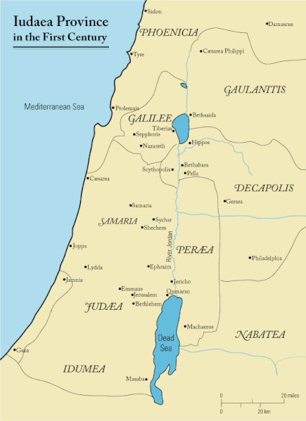
English: This is a map of first century Iudaea Province that I created using Illustrator CS2. I traced this image for the general geographic features. I then manually input data from maps found in a couple of sources.
  • Robert W. Funk and the Jesus Seminar. The Acts of Jesus. HarperSanFrancisco: 1998. p. xxiv.
  • Michael Grant. Jesus: An Historian's Review of the Gospels. Charles Scribner's Sons: 1977. p. 65-67.
  • John P. Meier. A Marginal Jew. Doubleday: 1991. p. 1:434.
Data 23 Martzu 2006 (original upload date)
Mitza Transferred from en.wikipedia to Commons.
Autore Andrew c at inglesu Wikipedia
Licèntzia
(Comente torrare a impreare custu documentu)
Released under the GNU Free Documentation License or CC-BY.
Àteras versiones العربيَّة

Litzèntzia

Andrew c from en.wikipedia.org, the copyright holder of this work, hereby publishes it under the following license:
GNU head Est permìtidu copiare, ispainare e/o modificare custu documentu sighende sas cunditziones de sa GNU Free Documentation License, Versione 1.2 o cale si siat versione prus noa publicada dae sa Free Software Foundation; chene peruna setzione fissa, perunu testu de cobertedda e perunu testu de palas. Una còpia de sa litzèntzia est inclùdida in sa setzione titulada GNU Free Documentation License. Subject to disclaimers.
w:en:Creative Commons
atributzione
Custu file est licentziadu in base a is tèrmines de sa licèntzia Creative Commons Atributzione 3.0 Unported.
Atributzione: Wikipedia User:Andrew c
Tue ses lìberu:
  • de cundivìder – de copiare, ispainare e trasmìtere s'òpera
  • de adatare – de adatare s'òpera
Suta de sas cunditziones chi sighint:
  • atributzione – Depes indicare s'autore comente si tocat, frunire unu ligàmene a sa litzèntzia e indicare si sunt istadas fatas modìficas. Lu podes fàghere in cale si siat manera chi tèngiat sensu, ma no in cale si siat manera chi diat s'idea chi su titulare de sa litzèntzia suportet a tie o a s'impreu tuo.
Public domain I, the copyright holder of this work, release this work into the public domain. This applies worldwide.
In some countries this may not be legally possible; if so:
I grant anyone the right to use this work for any purpose, without any conditions, unless such conditions are required by law.

Original upload log

The original description page was here. All following user names refer to en.wikipedia.
  • 2006-03-24 18:48 Andrew c 575×792×8 (32374 bytes) This is a map of First Century Palestine that I created using Illustrator CS2. I traced [http://commons.wikimedia.org/wiki/Image:Map_of_administrative_regions_in_Israel.png this] image for the general geographic features. I then manually input data from m
  • 2006-03-23 19:48 Andrew c 587×790×8 (30752 bytes) This is a map of First Century Palestine that I created using Illustrator CS2. I traced [http://commons.wikimedia.org/wiki/Image:Map_of_administrative_regions_in_Israel.png this] image for the general geographic features. I then manually input data from m

Captions

Add a one-line explanation of what this file represents
Judaea province in the 1st Century CE

Items portrayed in this file

depicts inglesu

Judaea inglesu

MIME type inglesu

image/gif

checksum inglesu

e488e0183049d2138c916ccc7a24c107807f12b7

determination method inglesu: SHA-1 inglesu

data size inglesu

32,019 byte

height inglesu

792 pixel

width inglesu

575 pixel

Istòria de su file

Carca unu grupu data/ora pro castiare su file comente si presentada in su tempus indicadu.

Data/OraMiniaturaDimensionesUtenteCumentu
atuale13:47, 18 Cab 2011Miniatura de sa versione de is 13:47, 18 Cab 2011575 × 792 (31 KB)OnceinawhileRemoved region-name "Philistia", as incorrect
16:05, 13 Cab 2007Miniatura de sa versione de is 16:05, 13 Cab 2007575 × 792 (32 KB)Liftarn{{SVG|map}} {{Information |Description=This is a map of first century en:Iudaea Province that I created using Illustrator CS2. I traced [http://commons.wikimedia.org/wiki/Image:Map_of_administrative_regions_in_Israel.png this] image for the general g
02:29, 30 Abr 2006Miniatura de sa versione de is 02:29, 30 Abr 2006575 × 792 (32 KB)Duende~commonswikihttp://en.wikipedia.org/wiki/Image:First_century_palestine.gif

Sa pàgina chi sighit impreat custu documentu:

Impreu globale de su documentu

Impreu de custu documentu in àteras wikis:

Càstia àteros impreos globales de custu documentu.