File:Boundaries of the Okinawan Languages.svg

Size of this PNG preview of this SVG file: 736 × 600 pixels. Àteras risolutziones: 295 × 240 pixels | 589 × 480 pixels | 942 × 768 pixels | 1,257 × 1,024 pixels | 2,513 × 2,048 pixels
Versione a risolutzione arta (file in formadu SVG, mannesa nominale 800 × 652 pixel, mannesa de su file: 21 KB)
Ogetu
| Descritzione |
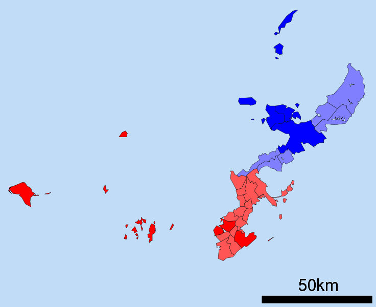
English: A map of the Okinawan Islands displaying the distribution of the Northern Okinawan Language (Kunigami) in blue, and the South-Central Okinawan Language (Shuri-Naha) in red. The darker areas represent regions that have been officially classified by the following sources:
|
| Data | (UTC) |
| Mitza | Map_of_Okinawa_Prefecture_Ja.svg |
| Autore |
|
| This is a retouched picture, which means that it has been digitally altered from its original version. Modifications: Removed the Daito, Yaeyama, Miyako and Yonaguni islands. Changed all the links to point towards their English Wikipedia counterparts. Changed the colours on the map to demonstrate the Okinawan language boundaries.. The original can be viewed here: Map of Okinawa Prefecture Ja.svg:
|
Litzèntzia
I, the copyright holder of this work, hereby publish it under the following licenses:
| Custu documentu est litzentziadu in base a is tèrmines de sa litzèntzia Creative Commons Atributzione-Cumpartzi a sa pròpria manera 3.0 Unported. | ||
| ||
| This licensing tag was added to this file as part of the GFDL licensing update. |

|
Est permìtidu copiare, ispainare e/o modificare custu documentu sighende sas cunditziones de sa GNU Free Documentation License, Versione 1.2 o cale si siat versione prus noa publicada dae sa Free Software Foundation; chene peruna setzione fissa, perunu testu de cobertedda e perunu testu de palas. Una còpia de sa litzèntzia est inclùdida in sa setzione titulada GNU Free Documentation License. |
Podes seletzionare sa litzèntzia chi boles.
Original upload log
This image is a derivative work of the following images:
- File:Map_of_Okinawa_Prefecture_Ja.svg licensed with Cc-by-sa-3.0-migrated, GFDL
- 2008-04-30T00:12:31Z Krisgrotius 800x652 (14670 Bytes) {{Information| |Description= Map of Okinawa Prefecture, Japan. |Source= Japanese wiki [http://ja.wikipedia.org/wiki/%E7%94%BB%E5%83%8F:%E5%8C%85%E6%8B%AC%E8%87%AA%E6%B2%BB%E4%BD%93%E5%8C%BA%E7%94%BB%E5%9B%B3_47000.svg] |Da
Uploaded with derivativeFX
Istòria de su file
Carca unu grupu data/ora pro castiare su file comente si presentada in su tempus indicadu.
| Data/Ora | Miniatura | Dimensiones | Utente | Cumentu | |
|---|---|---|---|---|---|
| atuale | 02:49, 25 Nad 2010 | | 800 × 652 (21 KB) | Io Katai | fixed links |
| 02:47, 25 Nad 2010 |  | 800 × 652 (21 KB) | Io Katai | Missed out on a few links | |
| 02:41, 25 Nad 2010 |  | 800 × 652 (21 KB) | Io Katai | {{Information |Description=A map of the Okinawan Islands displaying the distribution of the Northern Okinawan Language (Kunigami) in blue, and the South-Central Okinawan Language (Shuri-Naha) in red. The darker areas represent regions that have been offic |
Ligant a custu file
Sa pàgina chi sighit impreat custu documentu:
Impreu globale de su documentu
Impreu de custu documentu in àteras wikis:
- Impreu in ca.wikipedia.org
- Impreu in cdo.wikipedia.org
- Impreu in cs.wikipedia.org
- Impreu in en.wikipedia.org
- Impreu in et.wikipedia.org
- Impreu in fa.wikipedia.org
- Impreu in fi.wikipedia.org
- Impreu in gd.wikipedia.org
- Impreu in gl.wikipedia.org
- Impreu in gn.wikipedia.org
- Impreu in haw.wikipedia.org
- Impreu in hu.wikipedia.org
- Impreu in id.wikipedia.org
- Impreu in incubator.wikimedia.org
- Impreu in it.wikipedia.org
- Impreu in ja.wikipedia.org
- Impreu in ko.wikipedia.org
- Impreu in ms.wikipedia.org
- Impreu in pt.wikipedia.org
- Impreu in ru.wikipedia.org
- Impreu in simple.wikipedia.org
- Impreu in sr.wikipedia.org
- Impreu in sv.wikipedia.org
- Impreu in th.wikipedia.org
- Impreu in tr.wikipedia.org
- Impreu in uk.wikipedia.org
- Impreu in vi.wikipedia.org
- Impreu in zh-min-nan.wikipedia.org
- Impreu in zh.wikipedia.org