File:Holocaustdeathtoll%.png
Mannària de custa anteprima: 719 × 600 pixels. Àteras risolutziones: 288 × 240 pixels | 576 × 480 pixels | 921 × 768 pixels | 1,228 × 1,024 pixels | 2,457 × 2,049 pixels
Versione a risolutzione arta (2,457 × 2,049 pixels, mannesa de su file: 1.29 MB, tipu de MIME: image/png)
Ogetu
| Descritzione |
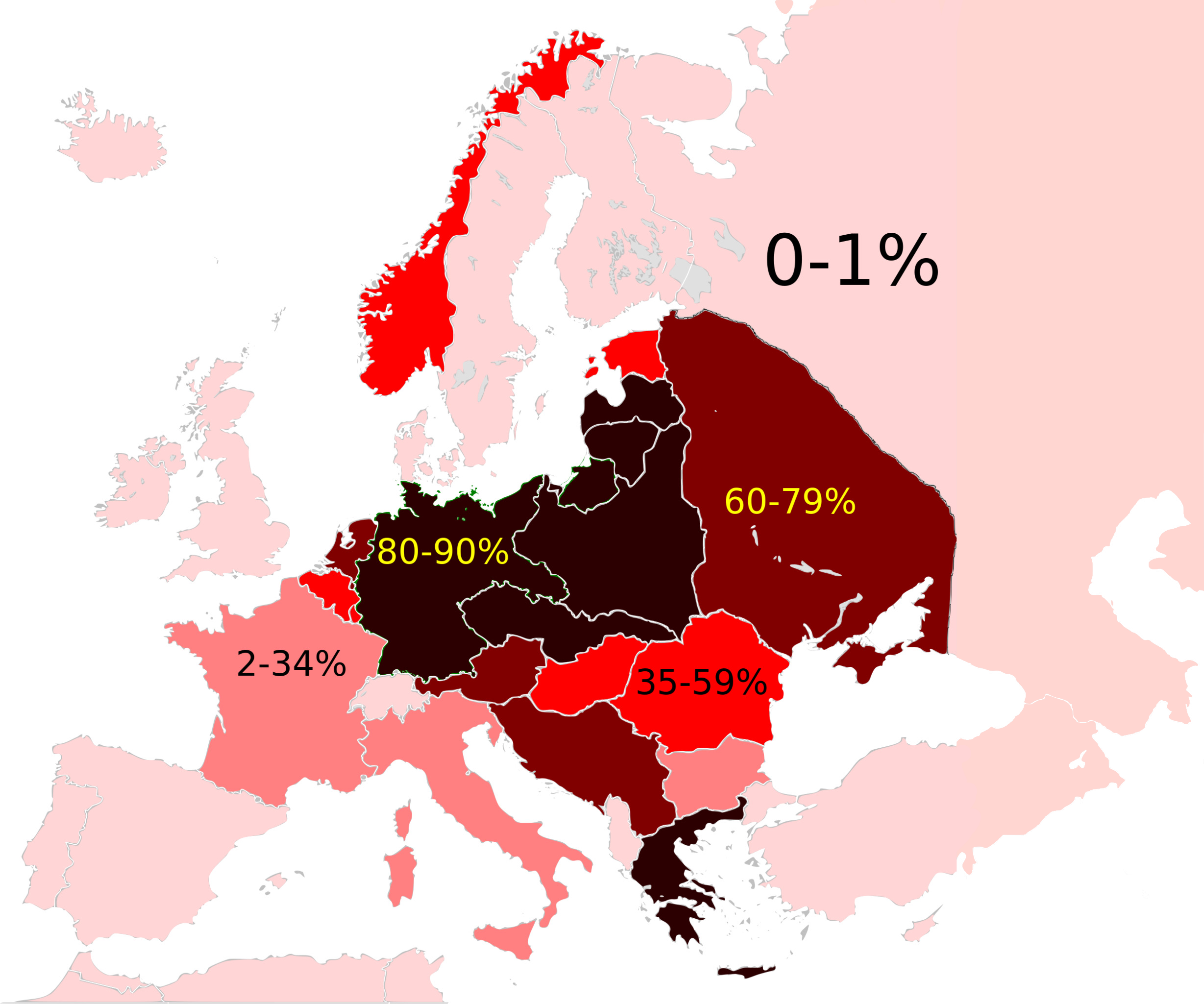
Map of the Jewish Holocaust death toll as a % of the total pre-war Jewish population by country/region
|
| Data | (UTC) |
| Mitza |
This file was derived from: Weimar Republic 1930.svg:  |
| Autore |
|

|
This historical map image could be re-created using vector graphics as an SVG file. This has several advantages; see Commons:Media for cleanup for more information. If an SVG form of this image is available, please upload it and afterwards replace this template with
{{vector version available|new image name}}.
It is recommended to name the SVG file “Holocaustdeathtoll%.svg”—then the template Vector version available (or Vva) does not need the new image name parameter. |
| This is a retouched picture, which means that it has been digitally altered from its original version. Modifications: Changed map. The original can be viewed here: Weimar Republic 1930.svg:
|
Litzèntzia
I, the copyright holder of this work, hereby publish it under the following license:
Custu documentu est litzentziadu in base a is tèrmines de sa litzèntzia Creative Commons Atributzione-Cumpartzi a sa pròpria manera 3.0 Unported.
- Tue ses lìberu:
- de cundivìder – de copiare, ispainare e trasmìtere s'òpera
- de adatare – de adatare s'òpera
- Suta de sas cunditziones chi sighint:
- atributzione – Depes indicare s'autore comente si tocat, frunire unu ligàmene a sa litzèntzia e indicare si sunt istadas fatas modìficas. Lu podes fàghere in cale si siat manera chi tèngiat sensu, ma no in cale si siat manera chi diat s'idea chi su titulare de sa litzèntzia suportet a tie o a s'impreu tuo.
- cumpartzi a sa pròpria manera – Si modìficas, trasformas, o isvilupas su materiale as a dèpere distribuire sos contributos tuos suta de sa matessi litzèntzia de s'originale o una cumpatìbile.
Original upload log
This image is a derivative work of the following images:
- File:Weimar_Republic_1930.svg licensed with Cc-by-sa-3.0
- 2011-10-27T03:00:17Z Alphathon 450x456 (480732 Bytes) Minor tweak
- 2011-10-27T02:49:21Z Alphathon 450x456 (480434 Bytes) Tweaked Romanian borders
- 2011-10-27T02:30:44Z Alphathon 450x456 (476278 Bytes) A few minor fixes (Malta grouped with UK, North Cyprus removed, a few Greek islands moved to Italy per 1930 ownership).
- 2011-10-27T02:10:50Z Alphathon 450x456 (477608 Bytes) == {{int:filedesc}} == {{Information |Description={{en|A Map of the Weimar Republic within Europe circa 1930.}} |Source=*[[:File:Blank_map_of_Europe.svg|]] |Date=2011-10-27 02:10 (UTC) |Author=*[[:File:Blank_map_of_Europe.svg
Uploaded with derivativeFX
Istòria de su file
Carca unu grupu data/ora pro castiare su file comente si presentada in su tempus indicadu.
| Data/Ora | Miniatura | Dimensiones | Utente | Cumentu | |
|---|---|---|---|---|---|
| atuale | 15:23, 3 Cab 2022 | | 2,457 × 2,049 (1.29 MB) | Рагин1987 | Extended map |
| 01:15, 16 Aus 2012 |  | 2,000 × 2,027 (593 KB) | Futurist110 | == {{int:filedesc}} == {{Information |Description={{en|Map of the Weimar Republic within Europe circa 1930.}}{{de|Karte der Weimarer Republik/Deutsches Reich innerhalb Europa, ca. 1930}} |Source={{Derived from|Weimar_Republic_1930.svg|display=50}} |Dat... |
Ligant a custu file
Sa pàgina chi sighit impreat custu documentu:
Impreu globale de su documentu
Impreu de custu documentu in àteras wikis:
- Impreu in ar.wikipedia.org
- Impreu in en.wikipedia.org
- Evidence and documentation for the Holocaust
- Aliyah Bet
- History of the Jews in Europe
- Wikipedia talk:WikiProject Israel/Archive 4
- Wikipedia talk:WikiProject Judaism/Archive 29
- User:OnBeyondZebrax/sandbox/The Holocaust
- Talk:The Holocaust/Archive 31
- Genocides in history (World War I through World War II)
- Impreu in es.wikipedia.org
- Impreu in fr.wikipedia.org
- Impreu in gl.wikipedia.org
- Impreu in hy.wikipedia.org
- Impreu in id.wikipedia.org
- Impreu in it.wikipedia.org
- Impreu in simple.wikipedia.org
- Impreu in sr.wikipedia.org
- Impreu in tr.wikipedia.org