File:Podgorica Montenegro.png
Podgorica_Montenegro.png (525 × 599 pixels, mannesa de su file: 456 KB, tipu de MIME: image/png)
| Descritzione |
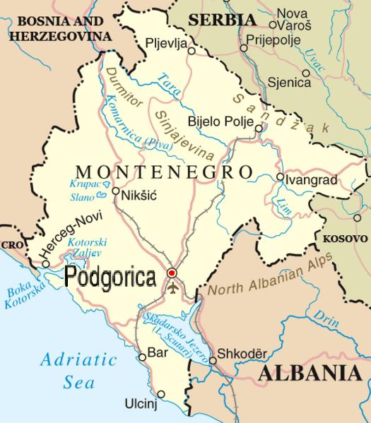
English: Map of en:Podgorica, en:Montenegro adapted by Madman from http://www.un.org/Depts/Cartographic/map/profile/yugoslav.pdf
by way of Image:Montenegro-bioce.png. |
| Data | 28 Ghennàrgiu 2006 (original upload date) |
| Mitza | Transferred from en.wikipedia to Commons by Drilnoth using CommonsHelper. |
| Autore | The original uploader was Madman2001 at inglesu Wikipedia. |

|
This map image could be re-created using vector graphics as an SVG file. This has several advantages; see Commons:Media for cleanup for more information. If an SVG form of this image is available, please upload it and afterwards replace this template with
{{vector version available|new image name}}.
It is recommended to name the SVG file “Podgorica Montenegro.svg”—then the template Vector version available (or Vva) does not need the new image name parameter. |
Litzèntzia
This file is in the public domain because permission given by UN as set out below
|
| This image is a map derived from a United Nations map.
Unless stated otherwise, UN maps are to be considered in the public domain. This applies worldwide. UN maps are, in principle, open source material and you can use them in your work or for making your own map. UN requests however that you delete the UN name, logo and reference number upon any modification to the map. Content of your map will be your responsibility. You can state in your publication, if you wish, something like: based on UN map … (map name, map number, revision number and date). See: Geospatial Information Section. And: Geospatial, location data for a better world. |
 |
Original upload log
- 2006-01-28 05:42 Madman2001 525×599× (466813 bytes) Better map of [[Podgorica]]], [[Montenegro]], adapted and edited by [[User:Madman2001|Madman]] from http://www.un.org/Depts/Cartographic/map/profile/yugoslav.pdf by way of Image:Montenegro-bioce.png == {{int:license}} == {{PD-because|permission given by UN as
- 2006-01-08 05:25 Madman2001 1920×1440× (924096 bytes) Author: Madman compiled from a number of sources, including satellite photos with hand-drawn towns and borders
- 2006-01-07 22:43 Madman2001 1920×1440× (708202 bytes) Author: Madman, using public domain satellite imagery for the geographic outline, with hand-drawn border and towns
Istòria de su file
Carca unu grupu data/ora pro castiare su file comente si presentada in su tempus indicadu.
| Data/Ora | Miniatura | Dimensiones | Utente | Cumentu | |
|---|---|---|---|---|---|
| atuale | 14:27, 31 Mar 2009 | | 525 × 599 (456 KB) | File Upload Bot (Magnus Manske) | {{BotMoveToCommons|en.wikipedia|year={{subst:CURRENTYEAR}}|month={{subst:CURRENTMONTHNAME}}|day={{subst:CURRENTDAY}}}} {{Information |Description={{en|Map of en:Podgorica, en:Montenegro adapted by Madman from http://www |
Ligant a custu file
Sa pàgina chi sighit impreat custu documentu: