File:Stonehenge Wide Angle.jpg

Mannària de custa anteprima: 800 × 600 pixels. Àteras risolutziones: 320 × 240 pixels | 640 × 480 pixels | 1,024 × 768 pixels | 1,280 × 960 pixels
Versione a risolutzione arta (1,280 × 960 pixels, mannesa de su file: 630 KB, tipu de MIME: image/jpeg)
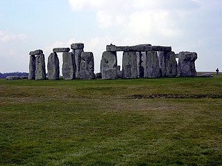
English: Full view of Stonehenge from the ground.
Slovenščina: Stonehenge od daleč.
| I, the copyright holder of this work, release this work into the public domain. This applies worldwide. In some countries this may not be legally possible; if so: I grant anyone the right to use this work for any purpose, without any conditions, unless such conditions are required by law. |
| Camera location | | View this and other nearby images on: OpenStreetMap |
|---|
Istòria de su file
Carca unu grupu data/ora pro castiare su file comente si presentada in su tempus indicadu.
| Data/Ora | Miniatura | Dimensiones | Utente | Cumentu | |
|---|---|---|---|---|---|
| atuale | 13:07, 4 Trì 2011 | | 1,280 × 960 (630 KB) | Citypeek | automatic white balance |
| 00:37, 4 Mar 2005 |  | 1,280 × 960 (579 KB) | Daveahern~commonswiki | Full view of Stonehenge from the ground |
Ligant a custu file
Sa pàgina chi sighit impreat custu documentu:
Impreu globale de su documentu
Impreu de custu documentu in àteras wikis:
- Impreu in ast.wikipedia.org
- Impreu in bg.wikipedia.org
- Impreu in ca.wikipedia.org
- Prehistòria
- Edat de pedra
- Paleolític superior
- Mesolític
- Epipaleolític
- Paleolític
- Paleolític inferior
- Paleolític mitjà
- Neolític
- Neolític antic
- Neolític mitjà
- Neolític final
- Eneolític
- Edat del bronze
- Edat del ferro
- Cultura dels túmuls
- Cultura dels camps d'urnes
- Cultura de Hallstatt
- Plantilla:Caixa Prehistòria
- Història de l'arquitectura
- Llista del Patrimoni de la Humanitat a Europa
- Tardenoisià
- Període de la ceràmica Mumun
- Impreu in cs.wikipedia.org
- Impreu in cy.wikipedia.org
- Impreu in da.wikipedia.org
- Impreu in de.wikipedia.org
- Impreu in en.wikibooks.org
- Impreu in eo.wikipedia.org
- Impreu in es.wikipedia.org
- Impreu in fr.wikipedia.org
- Impreu in gl.wikipedia.org
- Impreu in is.wikipedia.org
- Impreu in it.wikipedia.org
- Impreu in it.wikibooks.org
- Impreu in it.wikivoyage.org
- Impreu in mk.wikipedia.org
- Impreu in mzn.wikipedia.org
- Impreu in nn.wikipedia.org
- Impreu in no.wikipedia.org
Càstia àteros impreos globales de custu documentu.