File:Trockenklimate.png
Mannària de custa anteprima: 800 × 400 pixels. Àteras risolutziones: 320 × 160 pixels | 640 × 320 pixels | 1,024 × 512 pixels | 1,280 × 640 pixels | 3,600 × 1,800 pixels
Versione a risolutzione arta (3,600 × 1,800 pixels, mannesa de su file: 647 KB, tipu de MIME: image/png)
Ogetu
| Description |
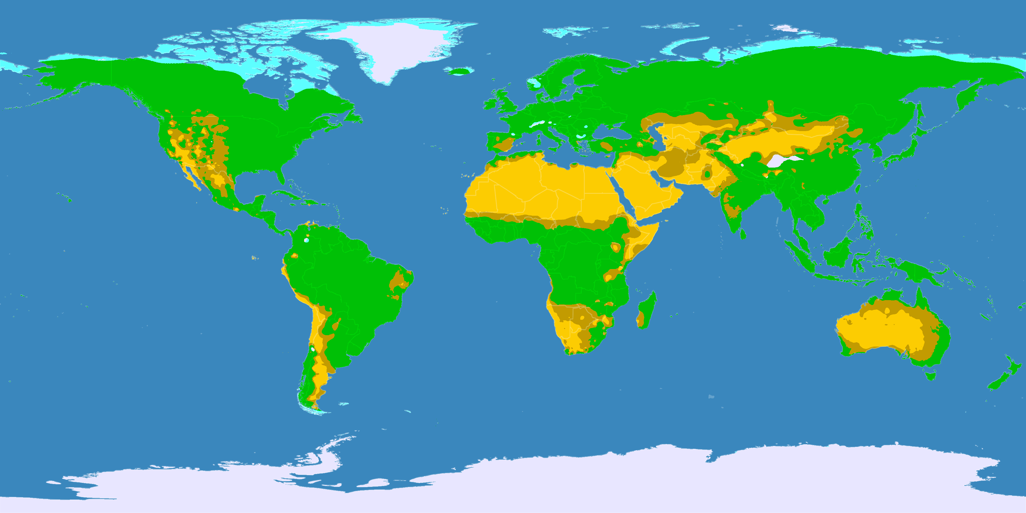
English: This map shows the Earth zones with a dry climate.
Desert climate
Savanna climate
Tundra climate
Ice cap climate
Deutsch: Diese Karte zeigt die verschiedenen trockenen Klimazonen der Erde.
Wüstenklima
Savannenklima
Tundrenklima
Eisklima
Italiano: Mappa delle zone desertiche
Deserto
Savana
Tundra
Clima glaciale
Norsk bokmål: Kart over verdens tørre klimasoner.
Ørken
Savanne
Tundra
Iskalottene |
||
| Data | |||
| Mitza |
English: Own work on the basis of the following data: Deutsch: Selbst erstellt auf Basis dieser Geodaten:
|
||
| Creator | |||
| Licèntzia (Comente torrare a impreare custu documentu) |
|||
| Georeferencing | If inappropriate please set warp_status = skip to hide. | ||
| Àteras versiones |
|


Litzèntzia
Custu documentu est litzentziadu in base a is tèrmines de sa litzèntzia Creative Commons Atributzione-Cumpartzi a sa pròpria manera 3.0 Unported.
- Tue ses lìberu:
- de cundivìder – de copiare, ispainare e trasmìtere s'òpera
- de adatare – de adatare s'òpera
- Suta de sas cunditziones chi sighint:
- atributzione – Depes indicare s'autore comente si tocat, frunire unu ligàmene a sa litzèntzia e indicare si sunt istadas fatas modìficas. Lu podes fàghere in cale si siat manera chi tèngiat sensu, ma no in cale si siat manera chi diat s'idea chi su titulare de sa litzèntzia suportet a tie o a s'impreu tuo.
- cumpartzi a sa pròpria manera – Si modìficas, trasformas, o isvilupas su materiale as a dèpere distribuire sos contributos tuos suta de sa matessi litzèntzia de s'originale o una cumpatìbile.
Istòria de su file
Carca unu grupu data/ora pro castiare su file comente si presentada in su tempus indicadu.
| Data/Ora | Miniatura | Dimensiones | Utente | Cumentu | |
|---|---|---|---|---|---|
| atuale | 23:03, 11 Stg 2016 | | 3,600 × 1,800 (647 KB) | Maphobbyist | The Caspian Sea was omitted. The Köppen system is based on the concept that climate types are correlated with the natural vegetation. |
| 14:25, 29 Ghe 2013 |  | 3,600 × 1,800 (530 KB) | GDK | humid areas colured green (formerly light grey) for better recognizability | |
| 19:25, 15 Stg 2007 |  | 3,600 × 1,800 (623 KB) | Lortordermur | == Beschreibung == {{Information |Description=Diese Karte stellt die trockenen Klimate der Erde dar. {{legend|#ffcc00|Wüstenklima}} {{legend|#c69e00|Savannenklima}} {{legend|#65ffff|Tundrenklima}} {{legend|#eaeaff|Eisklima}} |Source=Selbst erstellt auf |
Ligant a custu file
Sa pàgina chi sighit impreat custu documentu:
Impreu globale de su documentu
Impreu de custu documentu in àteras wikis:
- Impreu in ba.wikipedia.org
- Impreu in bg.wikipedia.org
- Impreu in ce.wikipedia.org
- Impreu in ckb.wikipedia.org
- Impreu in crh.wikipedia.org
- Impreu in da.wikipedia.org
- Impreu in da.wikibooks.org
- Impreu in de.wikipedia.org
- Impreu in de.wikiversity.org
- Impreu in eo.wikipedia.org
- Impreu in et.wikipedia.org
- Impreu in fa.wikipedia.org
- Impreu in fi.wikipedia.org
- Impreu in frr.wikipedia.org
- Impreu in hu.wikipedia.org
- Impreu in hy.wikipedia.org
- Impreu in hyw.wikipedia.org
- Impreu in inh.wikipedia.org
- Impreu in it.wikipedia.org
- Impreu in ja.wikipedia.org
- Impreu in kaa.wikipedia.org
- Impreu in ka.wikipedia.org
- Impreu in krc.wikipedia.org
- Impreu in la.wikipedia.org
- Impreu in lld.wikipedia.org
- Impreu in lv.wikipedia.org
- Impreu in nds.wikipedia.org
- Impreu in nl.wikipedia.org
- Impreu in no.wikipedia.org
- Impreu in pt.wikipedia.org
- Impreu in roa-tara.wikipedia.org
- Impreu in ro.wikipedia.org
- Impreu in ru.wikipedia.org
- Impreu in sr.wikipedia.org
- Impreu in sv.wikipedia.org
Càstia àteros impreos globales de custu documentu.