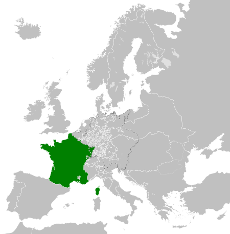
File:Kingdom of France (1789).svg

Size of this PNG preview of this SVG file: 450 × 456 pixels. Àteras risolutziones: 237 × 240 pixels | 474 × 480 pixels | 758 × 768 pixels | 1,011 × 1,024 pixels | 2,021 × 2,048 pixels
Versione a risolutzione arta (file in formadu SVG, mannesa nominale 450 × 456 pixel, mannesa de su file: 911 KB)
Ogetu


.svg)
.svg)
.svg)
.svg)
.svg)


.svg)
.svg)
.svg)


.png)
.png)


.svg)


.svg)

.svg)


.svg)
.svg)
.svg)
.svg)


.svg)
.png)


.svg)


.svg)
.svg)


.svg)


.svg)


.svg)
.svg)
.svg)
.svg)
.svg)
.svg)
.svg)
.svg)
_cropped.svg)
.svg)
.svg)
.svg)
.svg)
.svg)
.svg)
.svg)
.svg)
.svg)
.svg)
.svg)
.svg)
.svg)
.svg)
.svg)
.svg)
.svg)
.svg)
.svg)
.svg)
.svg)
.svg)
.svg)
.svg)
.svg)
.svg)
.svg)
.svg)
.svg)
.svg)
.svg)
.svg)
.svg)
.svg)
.svg)
.svg)
.svg)
.svg)
.svg)
.svg)
.svg)
.svg)
.svg)
.svg)
.svg)
Istòria de su file
Carca unu grupu data/ora pro castiare su file comente si presentada in su tempus indicadu.
| Data/Ora | Miniatura | Dimensiones | Utente | Cumentu | |
|---|---|---|---|---|---|
| atuale | 10:12, 17 Stg 2021 | | 450 × 456 (911 KB) | Fenn-O-maniC | Fixed the Russo-Swedish border to match the Treaty of Åbo of 1743 |
| 08:36, 29 Nad 2017 |  | 450 × 456 (914 KB) | TRAJAN 117 | Update | |
| 03:55, 25 Nad 2017 |  | 450 × 456 (832 KB) | TRAJAN 117 | +++ | |
| 04:14, 27 Aus 2013 |  | 450 × 456 (802 KB) | TRAJAN 117 | +++ | |
| 23:52, 7 Maj 2013 |  | 450 × 456 (839 KB) | TRAJAN 117 | {{Information |Description ={{en|1=The Kingdom of France in 1789.}} |Source ={{own}} {{AttribSVG|Europe 1789.svg|Alphathon}} |Author =TRAJAN 117 {{created with Inkscape}} |Date =2013-05-07 |Permission ... |
Ligant a custu file
Sa pàgina chi sighit impreat custu documentu:
Impreu globale de su documentu
Impreu de custu documentu in àteras wikis:
- Impreu in ar.wikipedia.org
- Impreu in arz.wikipedia.org
- Impreu in ast.wikipedia.org
- Impreu in az.wikipedia.org
- Impreu in be.wikipedia.org
- Impreu in bg.wikipedia.org
- Impreu in cs.wikipedia.org
- Impreu in da.wikipedia.org
- Impreu in de.wikipedia.org
- Impreu in el.wikipedia.org
- Impreu in en.wikipedia.org
- Impreu in es.wikipedia.org
- Impreu in fa.wikipedia.org
- Impreu in fi.wikipedia.org
- Impreu in fr.wikipedia.org
- Impreu in ga.wikipedia.org
- Impreu in gl.wikipedia.org
- Impreu in he.wikipedia.org
- Impreu in hr.wikipedia.org
- Impreu in hu.wikipedia.org
- Impreu in id.wikipedia.org
- Impreu in incubator.wikimedia.org
- Impreu in is.wikipedia.org
- Impreu in it.wikipedia.org
- Impreu in ja.wikipedia.org
- Impreu in ka.wikipedia.org
- Impreu in ko.wikipedia.org
- Impreu in lfn.wikipedia.org
- Impreu in lmo.wikipedia.org
- Impreu in lt.wikipedia.org
- Impreu in lv.wikipedia.org
- Impreu in ms.wikipedia.org
- Impreu in no.wikipedia.org
Càstia àteros impreos globales de custu documentu.
.svg)
.svg)